Explosive ordnance contamination map
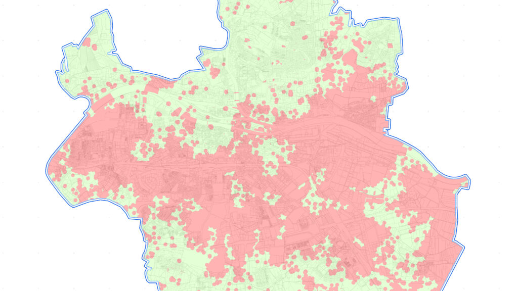
Explosive ordnance contamination map
Order
- Explosive ordnance contamination map, combined source and aerial photo evaluation.
- Basis: Analysis of approx. 3,400 aerial photographs from several time periods between 1941 and 1945.
- Historical Research.
Area Size
- 80 km2.
Results
- Approximately 50% of the project area is at risk of encountering unexploded bombs of various calibers.
- According to the construction guidelines for explosive ordnance disposal, there is a need for further investigation in the designated areas (category 2). To clarify the further procedure, we recommend consulting a specialist planner for explosive ordnance disposal or a specialist company for explosive ordnance disposal. The latter must be licensed in accordance with Section 7 of the Explosives Act (SprengG) and have the appropriate personnel with a certificate of competence in accordance with Section 20 of the Explosives Act (SprengG).
- For all other areas, no suspicion of explosive ordnance could be identified. According to the construction guidelines for explosive ordnance disposal, no further action is required here (category 1).
Luftbilddatenbank Dr. Carls GmbH | Sieboldstraße 10 | D-97230 Estenfeld | +49 (0) 9305 90 00 20 | Privacy Policy | Imprint | Contact